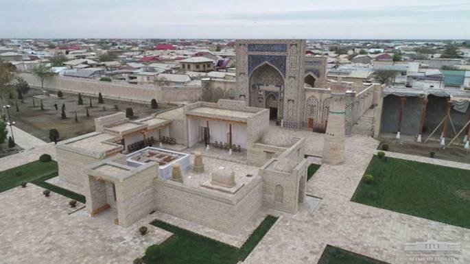
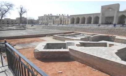
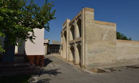
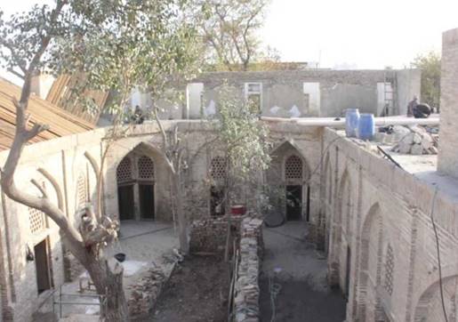
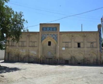
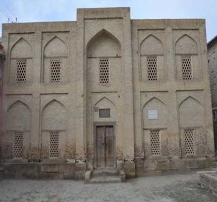
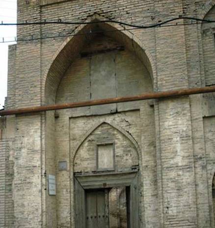
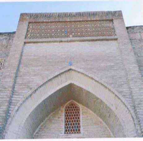
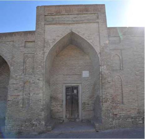
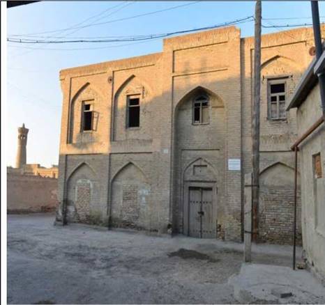
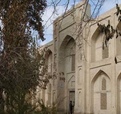
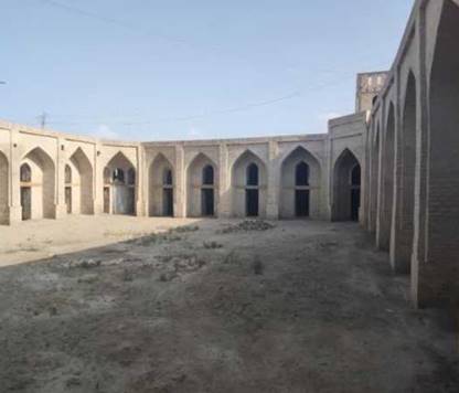
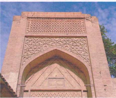
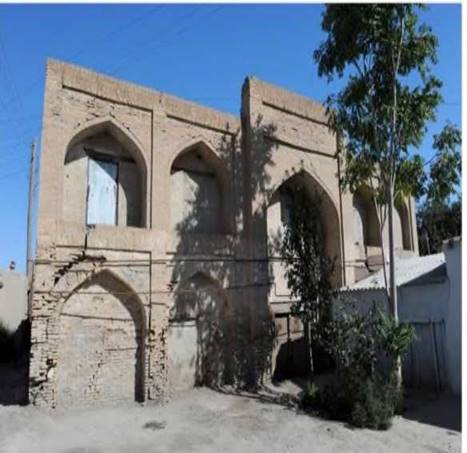
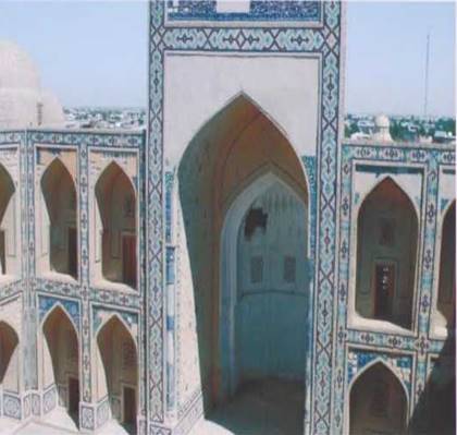
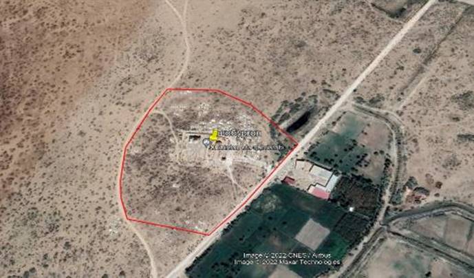
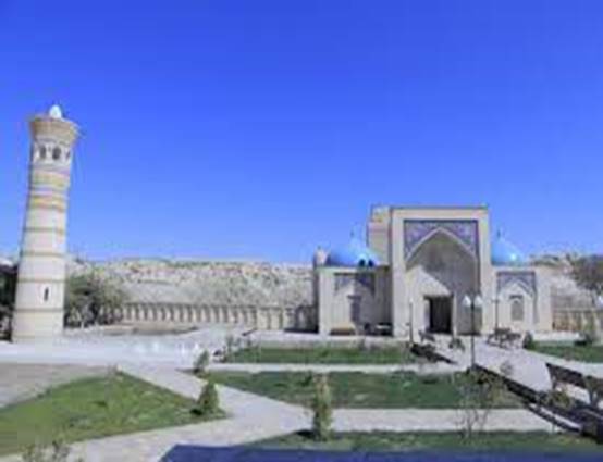
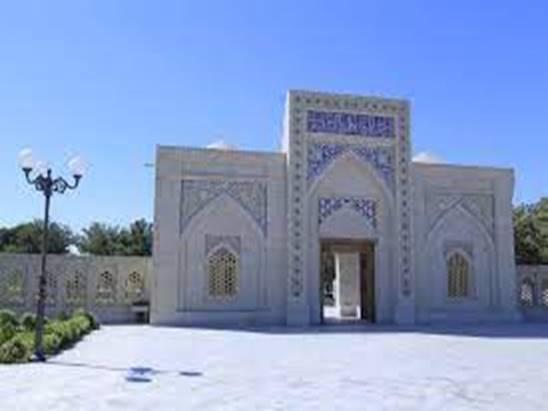
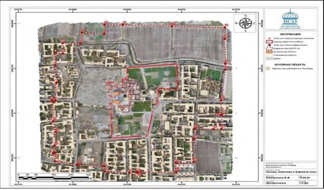
Madrasah Modarikhan
Object
type: Architectural monument
Abdullakhan and Modarikhan madrasahs,
built in the Kush style in front of the entrance of the Somani region culture
and recreation center, are unique monuments of Bukhara architecture. At that
time, the buildings built in the "^ush" method were considered to be
the most impressive traditional architectural buildings. Modarikhan madrasa,
built by Abdullah Khan in honor of his mother in 1566-1567, is a five-century
symbol of kindness and love, a monument of respect to the great. In the annals
of one of the historians of the palace, it is written that "its high
pediments and high domes, upper and lower buildings and foundations are very
solidly made from bottom to top." The size of the madrasah is 67x45 m, and
it is made up of two-story cells. A huge pediment in the style of the head and
two floors on both sides of it, the rooms divided into three rooms with a front
porch are decorated with tile patterns in the geometric style. In the corners
there are bouquets decorated with fishes.
region
(city): Bukhara region
district:
Bukhara city
The
name of the residents of the neighborhood is "Khuja Gunjariy" MFY
street
name (or other identifying address): Mirdustim street
Period: 16th century
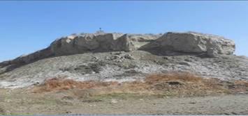
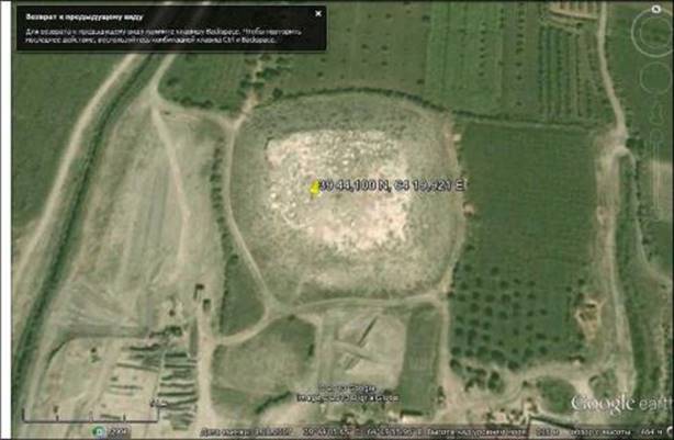
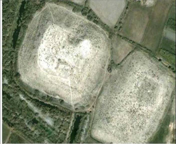
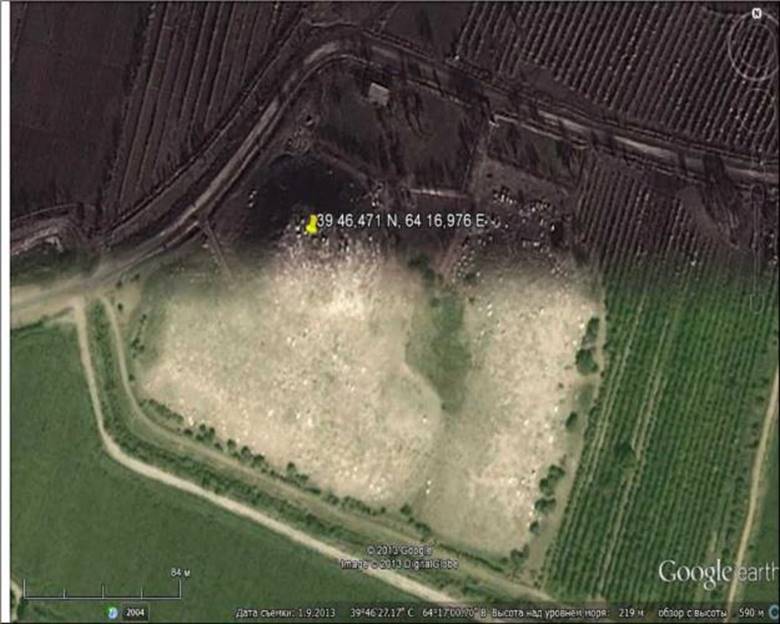
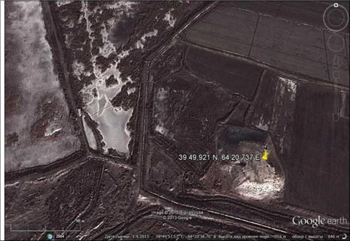
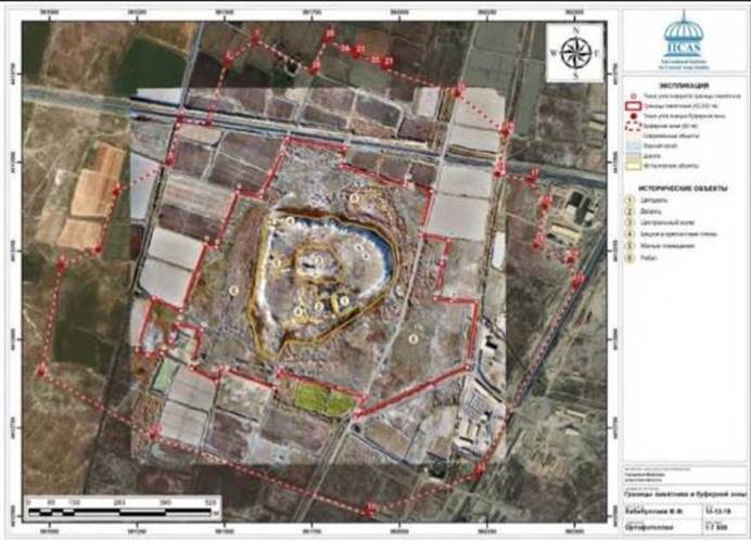
Poykent Fortress
Object
Type: Archaeology memorial
In the works of medieval Arab historians Narshahi,
Tabari, Ibn al-Khordadbek, Ibn al-Faqih, etc., it was known as "Madina
al-Tujjar" - "City of Merchants", which was the "Pearl
monad" city of Sogd in ancient times, the ancient city of Poykent is from
Bukhara.55 kmIt is located in the south-west, in the territory of the Karakol
district.
According to historical sources, the Poykents were skilled
traders who brokered trade between China and Iran. They sailed and traded in
the southern seas and were very rich.
According to the opinions of many researchers, Poykent
became "the only free city in Central Asia, a merchant republic" in
the 7th and early 8th centuries.
The city began to form in the IV century BC. It
becomes one of the major cities of the region from the 6th century. Istakhri
and Ibn Havqal wrote that Poykent was surrounded by strong defensive walls in
the 10th century, that there was a skillfully built mosque, and that the
mosque's mihrab was decorated with gold and precious stones, so it could not be
compared to Movarounnahr.
Narshahi writes that up to 240 years (854-855), along
with high buildings, more than 1000 robots were built in front of the city
gates in Poykent.
The ancient fortifiers skillfully used the terrain to
build the city and found a convenient solution for defense. The core of the
city is built on the highest natural hill and is 1. consisting of an area. Ark,
a religious and political center, existed in the VI-III centuries BC. It is
surrounded by a strong defensive wall. every 1214
meterssurrounded by square and semi-circular watchtowers. The city was formed
based on certain architectural laws. Ark, cities 1 and 2 consisted of a large
number of robots, castles and castles outside the defensive walls. In the city,
there were special sewage networks that provided clean drinking water to the
population areas and discharged waste water. Sidewalks covered with special stone
tiles are installed on the edges of the streets.
region
(city): Bukhara region
district:
Karakol district
name
of neighborhood citizens' assembly: Shorabod MFY
street
name (or other identifying address): Shorabod village
house
number:
Period: e.av VI-III-
XII centuries of our era
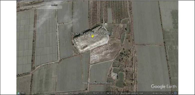
Poykent city
Object
type: Archaeological monument
In the works of medieval Arab historians Narshahi,
Tabari, Ibn al-Khordadbek, Ibn al-Faqih, etc., it was known as "Madina
al-Tujjar" - "City of Merchants", which was the "Pearl
monad" city of Sogd in ancient times, the ancient city of Poykent is from
Bukhara.55 kmIt is located in the south-west, in the territory of the Karakol
district.
According to historical sources, the Poykents were
skilled traders who brokered trade between China and Iran. They sailed and
traded in the southern seas and were very rich.
According to the opinions of many researchers, Poykent
became "the only free city in Central Asia, a merchant republic" in
the 7th and early 8th centuries.
The city began to form in the IV century BC. It
becomes one of the major cities of the region from the 6th century. Istakhri
and Ibn Havqal wrote that Poykent was surrounded by strong defensive walls in
the 10th century, that there was a skillfully built mosque, and that the
mosque's mihrab was decorated with gold and precious stones, so it could not be
compared to Movarounnahr.
Narshahi writes that up to 240 years (854-855), along
with high buildings, more than 1000 robots were built in front of the city
gates in Poykent.
The ancient fortifiers skillfully used the terrain to
build the city and found a convenient solution for defense. The core of the
city is built on the highest natural hill and is 1. consisting of an area. Ark,
a religious and political center, existed in the VI-III centuries BC. It is
surrounded by a strong defensive wall. every 1214
meterssurrounded by square and semi-circular watchtowers. The city was formed
based on certain architectural laws. Ark, cities 1 and 2 consisted of a large
number of robots, castles and castles outside the defensive walls. In the city,
there were special sewage networks that provided clean drinking water to the
population areas and discharged waste water. Sidewalks covered with special
stone tiles are installed on the edges of the streets.
region
(city): Bukhara region
district:
Karakol district
name
of neighborhood citizens' assembly: Shorabod MFY
street
name (or other identifying address): Shorabod village
house
number:
Period: VI-XII
centuries
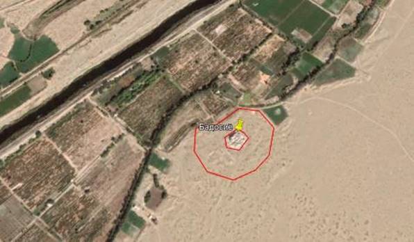
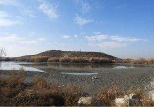
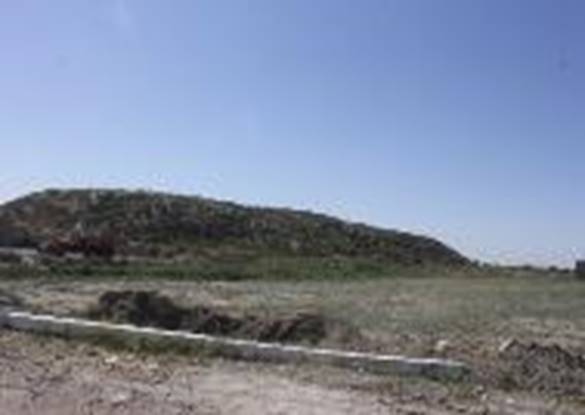
Badasiya hill
Object
Type: Archaeology memorial
The monument is located 2.5 km northeast
of Paykend settlement and is clearly visible from afar. It represents the ruins
of an early medieval castle. The immediate surroundings of the castle are
covered with sand, and the rest of the area is covered with vineyards.
The monument consists of two parts: the
castle itself and the residence in the castle. The part of the fortress is
square (24x22.5 m) in plan, strong walls 8 m high have been preserved. cliffs.
The building itself was built on a pakhsov platform 5.20 m high, the structure
was fully excavated, in 7 rooms there are remains of wall paintings in the form
of decorations of semicircle and trapezoidal shapes, mostly painted in blue
with red paint. background has been identified. Dark gray and green paints were
also used.
The residence in the castle was located at
the foot of the building on the southwest face. Its insignificant remains have
been preserved. The settlement was square in plan (17x17 m), surrounded by a
circular wall, and it was possible to determine the presence of buildings
inside.
The feudal peasant lived in the castle
with his household members, and the servants and slaves lived in the residence.
The castle was apparently built in the
early Middle Ages (VII-VIII centuries). The castle was destroyed by fire in the
9th-10th centuries. settled episodically. In 1954 and 1956, as a result of the
archaeological work carried out by the detachment of the Institute of History
and Archeology of the Academy of Sciences of the Republic of Uzbekistan, the
monument was fully explored, and the results were reflected in the publication
of G.V. Shishkin (109).
region
(city): Bukhara region
district:
Karakol district
name
of neighborhood citizens' assembly: Shorabod MFY
street
name (or other identifying address): New development array
house
number:
Period: VII-VIII
centuries
Friendly hill
Object
Type: Archaeology memorial
The monument is located about 10 km south of Paykend
settlement in the steppe zone, in an area covered with hard sand and overgrown
with saxophone.
The monument is rectangular in shape, the
corners are rounded, the area is 100x65 m, it stretches from the northeast to
the southwest. The north-eastern part of the monument is square in plan with an
area of 65x65 m, and it rises to a height of about 5.5 m above
the surrounding level. The surface of this part of the army rises gradually
towards the middle.
The highest part on the southwest side is
connected by a flat platform with an area of 65x35 m. The height
of this settlement is about 3 m.
Apparently, the monument is located on a
slope from the northeast to the southwest.
The entire territory of the settlement is
covered with fragments of baked bricks, glazed and unglazed ceramics dating
back to the IX-X, XI-XII and XVI centuries, but the appearance of the monument
most likely dates back to earlier periods.
region
(city): Bukhara region
district:
Karakol district
name
of neighborhood citizens' assembly: Kulonchi MFY
street
name (or other identifying address): Kulonchi village
house
number:
Period: Middle
Ages
Kumsultan
Object
Type: Archaeology memorial
The monument is located in the steppe zone, 30 km
southeast of the city of Paykend, on the shore of the ancient, dry bottom of
Kashkadarya.
The settlement is oriented along the
north-south line with a slight deviation to the northwest. Consists of three
parts. The highest castle (height 9 m) has a rectangular contour with an area
of 120x100 m. The surface of the castle has a slope from west to
east. Along the edges of the fort, traces of stone walls can be observed in
some places. The steepest side is the western slope.
The
surface of the castle is covered with pieces of baked bricks and fragments of
ceramics from the 7th-8th, 9th-12th centuries. No earlier pottery was found.
But many coins of BC and the first centuries AD, found by G. V. Shishkina, A.
R. Mukhamedjonov and others, published by E. V. Zeymal, came from the
settlement. Many fragments of glass and bronze objects were also found in the
ascent.
region
(city): Bukhara region
district:
Karakol district now (territory of Bukhara district)
name
of neighborhood citizens' assembly: Bukhara district
street
name (or other identifying address): Kumsultan massif
house
number:
Period: VII-VIII
and IX-XII centuries
Shoburg'an father
hill
Object
Type: Archaeology memorial
The
monument is located 5 km north of Karakol, 12 km north-west of Paykend. This
architectural complex is a mausoleum, in which, according to legend, the hero
of the people who led the fight against the Mongol invaders was buried and is
an object of respect and pilgrimage for the local population.
Beneath the architectural complex is a
small settlement, apparently consisting of two parts, stretching from north to
south. The part of the castle in its current state is higher, surrounded by an
architectural monument, surrounded by a brick wall and an iron fence - it is
located in the northern part of the monument. It is a hill with a rectangular
plan (100x60 m), height 7-8 m. Fragments of an ossuary were found here during a
visit in the early 70s of the last century. The raised materials related to the
settlement date from the early Middle Ages to the 11th-18th centuries. This
settlement is related to the Amdiz fortress and, according to sources (Makdisi,
Samani), is located on the border of the sandy steppe between Paykend and Farob
along the trade route.
No damage is observed in the non-existent
state. Ceramic and brick fragments belong to the 10th-13th centuries. Unglazed
pottery of the 17th-18th centuries - tagora, lamp fragments, 14th-century
architectural decorations with mosaic patterns and blue glaze are noted in the
upper horizon.
The
site of the architectural complex and the ancient settlement has been studied
several times by the ANRUz Institute of Archeology and History.
region
(city): Bukhara region
district:
Jondor district
name
of the community assembly: Karoli MFY
street
name (or other identifying address Yangimozor village desert area
Period: V-XVIII
centuries
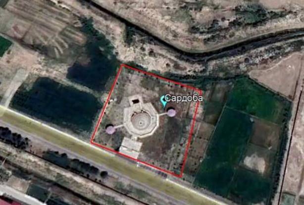
Sardobai
Qarovulbazar
Object Type:
Architecture
The hot climatic
conditions of Central Asia and the provision of water to large cities encourage
the construction of cisterns in cities. Many cisterns were built by Abdullah
Khan II, including the Qarovulbazar and Bozachi cisterns. The cisterns were
mainly created in connection with livestock and caravan routes. Most of the
preserved cisterns in our republic were created in the 14th-16th centuries. The
Qarovulbazar Reservoir is located near the city center, the cistern has 3
gates, the width of the pool is 15 meters. It is built in the form of a
circular pool and a dome covering it. There is a special entrance for taking
water from the cistern. In ancient times, there was a well near the reservoir and
it was used for watering livestock
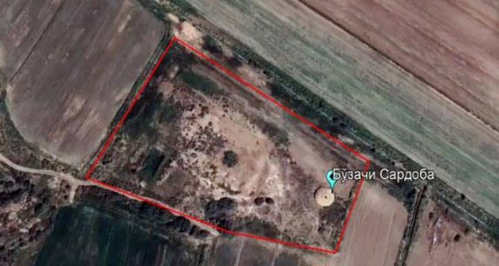
The Bozachi cistern,
located 17 km from the Qarovulbozor cistern, is much smaller than the
Qarovulbozor cistern and has three windows and an entrance. Its diameter is 13
meters. This cistern is also affected by the salinity of the earth in some
places. At the same time, the pool was buried. This cistern is in a very bad
condition. It is a pity that today that land is a place for sheep.
region
(city): Bukhara region
city:
Korovulbazar district
name
of neighborhood citizens' assembly: Chulquvar MFY
street
name (or other identifying address): near the Bukhara-Karshi railway
Period: 16th
century
Bozachi cistern
Object Type:
Architecture
The hot climatic
conditions of Central Asia and the provision of water to large cities encourage
the construction of cisterns in cities. Many cisterns were built by Abdullah
Khan II, including the Qarovulbazar and Bozachi cisterns. The cisterns were
mainly created in connection with livestock and caravan routes. Most of the preserved
cisterns in our republic were created in the 14th-16th centuries. The
Qarovulbazar Reservoir is located near the city center, the cistern has 3
gates, the width of the pool is 15 meters. It is built in the form of a
circular pool and a dome covering it. There is a special entrance for taking
water from the cistern. In ancient times, there was a well near the reservoir
and it was used for watering livestock
The Bozachi cistern,
located 17 km from the Qarovulbozor cistern, is much smaller than the Qarovulbozor
cistern and has three windows and an entrance. Its diameter is 13 meters. This
cistern is also affected by the salinity of the earth in some places. At the
same time, the pool was buried. This cistern is in a very bad condition. It is
a pity that today that land is a place for sheep.
region
(city): Bukhara region
city:
Korovulbazar district
name
of neighborhood citizens' assembly: "Bozachi" MFY,
street
name (or other identifying address): Buzachi village
Period: 16th
century
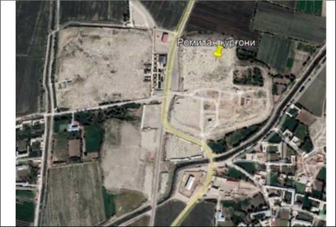
Rometan fortress
Object type: Archaeological
monument
5.
BRIEF HISTORY OF THE FACILITY
The
fortress of Romitan is one of the largest archaeological monuments of the
Bukhara region. It is the ruins of the Romitan city (village), which functioned
during the Great Middle Ages, that have survived to our days. In medieval
written sources, the city is mentioned as one of the largest population centers
of Farbiy SuFd, in some sources as a city, and in other sources as a village.
In Arabic and Persian sources of the 9th-11th centuries, his name is
interpreted in different ways, for example, in the works of an-Narshahi and
an-Nishaburi, Ramtin, Ramisan in al-Istakhri, Aryamisan in al-Mukaddasi,
Ramisan in al-Sam'ani, Armisana, Zamisan in Yakut al-Hamawi. , Zamisana and
others (Kamaliddinov, 1993, p. 68). These are the names of a large ancient
stream flowing near the city.
Romitanrud,
as one of the main sources of water produced in the Vobkent Darya, irrigated
the farms and cultivated fields of the inhabitants of the city of Romitan and
its ancient villages.
Since
Romitan is one of the big cities of Bukhara region, the history of its
emergence has been interesting to historians since ancient times, and there are
different stories about the formation of this city. In the work "History
of Bukhara" (Khasr) by Muhammed Narshahi, there are expressions about this
ancient city as the first capital of the world and even older than Bukhara.
According to Muhammed Narshahi, the city of Romitan was originally known as
Bukhara, and this city was one of the main residences of the rulers of Bukhara.
This information is also given in the works of the historian al-Mukaddasi.
The
importance of the city is described by the historian in other words. For
example, KurFOn Romitan was the residence of Turanian king Afrosiyab in ancient
times, and here Afrosiyob's daughter was cured by the wonderful air of Romitan
and got rid of the head OFriFi. It is also recorded that the king of Bukhara,
Romitan, came to Bukhara as a bride and brought a temple with her from China.
According
to the narration given by An-Nisaburi, the city was founded by an unknown king
who ruled after a prince named Sheri Kishwar. Sheri Kishvar was the Turkish
prince who ruled Bukhara for the first time. If we can draw a conclusion from
the opinions of this author, the city was built approximately during the VI-VII
centuries.
After
Khumijkat (the ancient name of Bukhara) became the capital of the city and the
city, the Pashoks visited Romitan only to visit. By the time of Islamic rule,
Romitan lost its status as a city, and in the written sources of this period it
is mentioned as a village. Despite this, in 751-752, Abu Muslim, who conquered
Sufdan, built his residence here.
In
the Chinese chronicles of the Tang Dynasty (618-907), Romitan is mentioned as
Alanami, the residence of the governor of Ansu, but the local people call the
country Buho (Bukhara). These data refer to the years 656-661.
Information
from written sources shows that Romitan was the capital of Farbiy SuFd, the
main residence of Turkish rulers, for about 70 years, from the VI-VII
centuries, until the end of the 60s of the VII century.
In
the 70s of the 7th century, on the eve of the conquest of Movarunnahr by the
Arabs, the capital of the Bukhara region lost its independence to Numijkat. The
string of the name "Bukhara" VI-VII appeared
centuries ago
all
the written sources, as well as the inscriptions on the coins minted in Farbii
SuFd, confirm that he did not find it. Sufic word "pukhar" (Bukhara)
written on the surface of coins began to appear from the 7th century. Many
experts confirm that the term Bukhara originated from the Sanskrit word
"vihara", which means "Buddhist temple, monastery". Such a
temple certainly existed in Romitan, and the name of Bukhara is also mentioned
as the second name of the city of Romitan, and later the whole region and
finally the new capital city Numijkat will be called by this name. But the
capital's name Numijkat did not go out of use even in the 10th century.
According
to Al-Mukaddasi, at the time when this traveler arrived, the entire region was
called "Bukhara" and the capital of the region was called Numijkat.
Now,
if we think directly about the etymology of the name Romitan, this name means
Persian "rokh", that is, road, "misan", house, shelter",
that is, if we summarize them, it means a house on the road, or houses on the
road, or a village on the road. It is not without possibility that it means The
meaning of the name Romitan fully corresponds to the nature of its location,
because the city is located in the center of Farbi SuFd, on the caravan route
from SuFd to Khorezm.
region (city):
Bukhara region
District: Romitan
District
Local residents'
name: "Azizon" MFY
City name (or other
identifying address): Rabat village
Period: Middle Ages
Amirtepa
Object type: Archaeological monument
Amir
Tepa in Romitan district was built in the Middle Ages. This hill is registered
as an archaeological monument. At present, there are old pottery huts on this
hill, and the elders say that tribes lived there in the 30s.
region (city): Bukhara region
District: Romitan District
The name of the local community: "Chelongu"
MFY
Power
Name (or other identifying address): Suspatta Village:
Period: Middle Ages

Tally hispanitepa
Object type: Archaeological monument
The monument is located on the territory of BoFiturkon
MFY, Romitan district. The area is 202x145 meters. It can be seen that the
materials on the face of the monument belong to the Middle Ages.
region (city): Bukhara region
District: Romitan District
Name of neighborhood fusarolar yitini:
"Bogiturkon" MFY
Kucha
name (or anizing address in case): Bogiturkon village
Period:
Not identified
Hill 8 (Nufor Hill)
Object type: Archaeological
monument
The monument consists of an arch and a part of
the city located on the territory of Khazortut MFY, Novfach village. The area
of the arch part is 130x120 meters. The area of
Shkhriston part is 235x175 meters. The materials on the surface
of the monument belong to the Middle Ages.
region (city): Bukhara region
District: Romitan District
Name of local residents' yitin: "Kazortut"
MFY
Kucha
name (or other identifying address): Novfach village
Period: Middle Ages

Hill 11
Object type: Archaeological
monument
The monument consists of 3 hills. There are no
historical sources, scientific research should be carried out.
District: Romitan District
The name of the community's local community:
"Bogisaydan" MFY
power
name (or other identifying address): Bogisaidonkishlogi
2. FACILITY PERIOD AND CATEGORY
Period: Middle Ages

Khuja Zafaron Tepa 1
Object type: Archaeological
monument
V. Shishkin's "Varakhsha" work,
published in Moscow in 1963, contains rich scientific information about the
"Thousand Cities", Kizilkir hill, Khoja Ubbon, Khoja Za'faron saints
and many hills here, and it is confirmed by evidence that these areas were
inhabited in ancient times.
region (city): Bukhara region
District: Romitan District
The name of the local community yitini:
"Kokishtuvon" MFY
name
of the village (or other identifying address): Kokishtuvon village
Period: Middle Ages

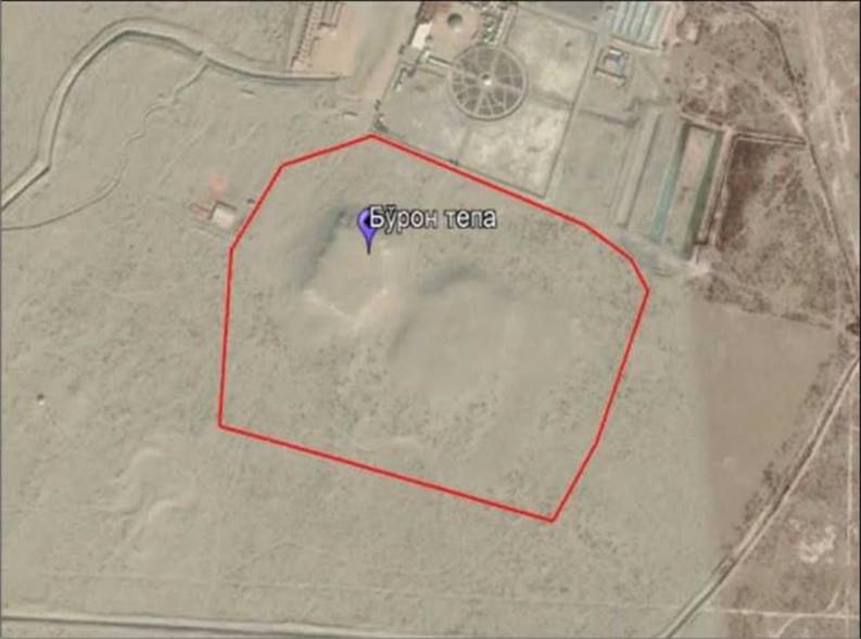
Burontepa
Object type: Archaeological
monument
V.
Shishkin's "Varakhsha" work, published in Moscow in 1963, contains
rich scientific information about the "Thousand Cities", Kizilkir
hill, Khoja Ubbon, Khoja Za'faron saints and many hills here, and it is
confirmed by evidence that these areas were inhabited in ancient times. .
region (city): Bukhara region
District: Romitan District
Name of local fusarolar yitini: Khuja Ubbon MFY
the
name of the power (or an anisizing address if it starts): Chul khududi
Period: Middle Ages
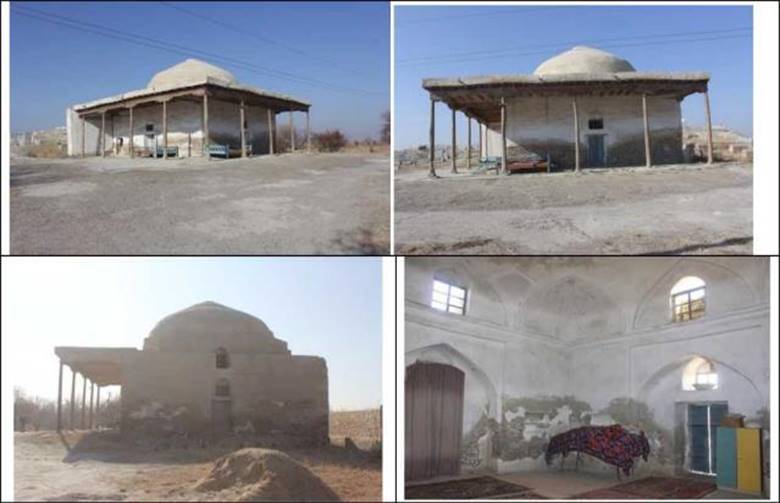
Azizan Mosque
Object Type:Architectural monument
Khuja
Ali Rometani is the 2nd student of Khuja Mahmud Anjir Fakhnavi. He said
"Khoja Azizon" in the vernacular. Khojai Hurd is a night child. His
name is Mahmud. This person was also a scholar, scholar and perfect person.
Khoja Ibrahim is the youngest son. This person is also a scientist, a scholar
and a perfect person. A rich spiritual heritage has been preserved from Khuja
Ali Rometani. They are: the work "Risalai Hazrati Azizon", 16
rashkhas - hikmats, 1 kita and 4 rubai. He was buried near the village of Romitaniy
Kurgon. A mausoleum was built near Kabri. The mausoleum has been repaired.
Currently, the shrine is being redecorated.
region (city): Bukhara region
city: Romitan district
The name of the neighborhood fusarolar yitini:
"Mugoncha" MFY
name
of the power (or anizing address if it starts): Alamdorkishlogi
Period:
XIX century

Stone mosque
Object Type:Architectural monument
The
Stone Mosque architectural monument was built in 1872 in the Stone Mosque
village of Chelonhu 1\Fy, Romitan District. To the state register as an object
of historical heritagereceived.
region (city): Bukhara region
city: Romitan district
Name of neighborhood fusarolar yitini:
"Chandir" MFY
the
name of the place (or if it is an anisizing address): Tashmasjid kishlogi
Period:
XIX century

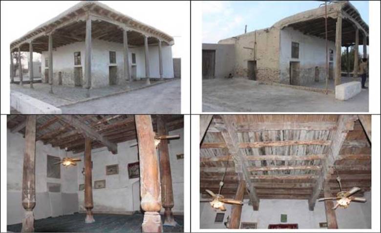
Mullomir's house
Object Type:Architectural monument
"Khokimullamir"
mosque was built in the 16th century. Navkari Dustimbek, which is owned by
Abdulla Khan, was built by ApFyH in honor of Mullomir. Room 21.5 X 17.5, height
- 20-22 meters. Today, it is one of the holy kadamjos, which is being renovated
and is constantly visited by pilgrims. The contribution of this shrine to the
development of tourism and travel in the future is very great.
region (city): Bukhara region
city: Romitan district
Name of neighborhood fusarolar yitini:
"Urganjiyon" MFY
the
name of the village (or, if it is, anizing address): Hokimullamir village
Period: 16th century

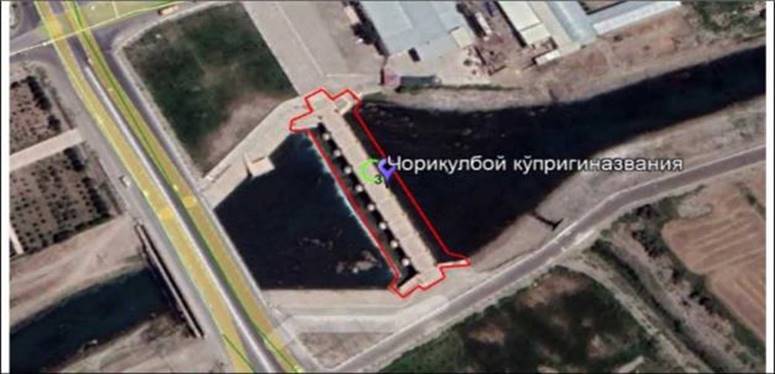
Chorikulboy bridge
Object type: Architectural
monument
It was built by the generous
and tanti Chorikulboy Pirnafasboy from Romitan. This is a famous bridge over
the Zarafshan River, 100 meters long and 8 meters wide. The famous Chorikulboy
bridge was built in 1911-1914. This bridge is called Chorikulboy bridge.
This
bridge is under state protection as a famous historical architectural monument.
The building was renovated in 2014 in connection with the 100th anniversary of
its construction. The surrounding areas are landscaped.
region (city): Bukhara region
city: Romitan district
Name of neighborhood fusarolar yitini:
"Afrosiyab" MFY
name
of the branch (or anizing address if it is the beginning): Amir Temur branch
street
Period:20th century
Khuja Ali Romitani "Azizon"
shrine
Object Type:A remarkable place
Khuja
Ali Rometani is the 2nd student of Khuja Mahmud Anjir Fakhnavi. He said
"Khoja Azizon" in the vernacular. Khojai Hurd is the son of Tunzich.
His name is Mahmud. This person was also a scholar, scholar and perfect person.
Khoja Ibrahim is the youngest node. This person is also a scientist, a scholar
and a perfect person. A rich spiritual heritage has been preserved from Khuja
Ali Rometani. They are: the work "Risalai Hazrati Azizon", 16
rashkhas - hikmats, 1 kita and 4 rubai. He was buried near the village of
Romitaniy Kurgon. A mausoleum was built near Kabri. The mausoleum has been
repaired. Currently, the shrine is being redecorated.
region (city): Bukhara region
city: Romitan district
The name of the neighborhood fusarolar yitini:
"Azizon" MFY,
Kucha
name (or anizing address in case): Sabristan village
Period: 16th century
Shrine of Khuja Muhammed Babayi
Samosi
Object Type:A remarkable place
Khoja Muhammed Boboyi Samosiy, Bukhara region, Romitan
district, now "Boboyi Samosiy" MFY Samos (in some sources it is
called Simos) was born in kishloxiaa and died here in 1354.
Nowadays,
the barricades on the road leading to "Khoja Muhammad Babai Samosi"
have been replaced and the road has been repaired. The old walls around the
shrine have been removed and the territory of the shrine has been expanded. .
The contribution of this shrine to the development of tourism and travel in the
future is very great.
region (city): Bukhara region
city: Romitan district
The
name of the neighborhood fusarolar yitin: "Samos" MFY,
the
name of the place (or anizing address in case): Koshur village
Period: 16th century
Tomb of Khuja Ubon
Object type: Place of
interest
Khoja Ubbon Shrine is 40 kilometers north-west of
Bukhara citybeyond, or 20 kilometers north-west of Varakhsha hill, is a settlement
located among the sum hills. In most of the hills located in this distance, you
can find heaps of Sadim pottery and sinis of ripe khishts. Scientific studies
indicate that these soldis mainly belong to the melodic IX-XI centuries.
Between Chandirtepa and Subbustepa, there are also old ruins of aris, which
provided life to the village from the south to the north-west. On both sides of
the entrance gate of the shrine, there is a new design of the national flagA mausoleum was built in the
style of national architecture on the sagana where the body of Khoja Ubbon was
laid. The area around the stone well has been restored to its former state, and
the well has been cleaned and restored to a usable condition. In 2008-2010, in
the place where the saint's head was blown off and buried, the old wooden
mausoleum and sagana were restored and a mahogany mausoleum was built instead.
The surroundings of the shrine are beautified.
region (city): Bukhara region
city: Romitan district
The name of the neighborhood fusarolar yitini:
"Khuja Ubbon" MFY,
Kucha
name (or anizing address in case): Khuja Ubban village
Period: 16th century

Tomb of Khuja
Zafaron
Object type: Place of
interest
Khoja
Za'faron - Muhammad Ibn Vose' Al-Bukhari, a noble saint who lived in the
VII-VIII centuries, a scholar of hadith science, a scholar of medicine, who
made a great contribution to the practical and theoretical development of folk
medicine. considered a good doctor.
region (city): Bukhara region
city: Romitan district
Name of neighborhood fusarolar yitin: "Kokishtuvon"
MFY,
Kucha
name (or anizing address in case): Kokishtuvon Sislogi
Period: 16th century

Vardonze
Bay
Object type: Archaeological monument
Vardanze settlement
is one of the most famous historical monuments of Bukhara region. This ancient
city is often mentioned in medieval written sources. On the other hand, during
the first centuries, it was the capital of a small but rich and powerful
principality, whose rulers competed equally with the Uzi kings of Bukhara - the
Bukhara lords. The famous late-century historian Muhammed Narshahi (10th
century) from the village of Narshok near Vobkent called this ancient city
Vardana, the author of the book "History of Bukhara". It is mentioned
under the same name in the works of Arab historians and geographers of the 10th
century: al-Istakhri ("Kitab al-Ma-salik wa-l-Mamalik" - "book
of lands and countries") and at. -Tabari ("Tarihi al-Mulk wa-l-Rasuli
- "History of kings and prophets"). Another Arab geographer
al-Mukaddasi ("Akhsan al-takhsim fi marifat al-kalim") who lived in
the 10th century called it this. point Avarzana. And two more Arab geographers
al-Samani ("Kitab al- Ansab" - "Book of Proportions", 15th
century) and Yakut al-Khamavi ("Mu, Jam al-Buldan" -
"Encyclopedia of Cities"). ", XIX century) in the Uz variants,
give the following variants: Vardana or Varzan According to the opinion of the
last two authors, there were two villages with the same name Vardana or
Varzanzi in the territory of the Bukhara region.
The authors of the Middle Ages mostly provided
piecemeal information on urban khaki. Thus, al-Istakhri placed Vardan near the
Safar channel. Al-Mukaddasi called Avarzana (Vardana) a "city-like
village". Al-Sam'ani and Yakut al-Hamawi considered this point as a
village. This is surprising, because after the Arab conquest, Vardan lost its
former importance as one of the political centers of Farbii Sutd and became one
of the regional centers that united the rustic village district from an
economic point of view. Beyond that, in Vardan, apparently, the cathedral
mosque was a burden. If so, the authors would certainly have recorded this
fact. At that time, the presence of the cathedral mosque was one of the main
features that distinguished the city from the countryside. The most detailed
information on Vardan khaki is preserved in Narshahi's book.
region (city): Bukhara region
district: Shafirkon district
Name
of local community center: BogiafzalMFY
Period: e.av VI-XVIII centuries

Top it off
Object type: Archaeological monument
The monument is
located on the highway near Undari village. This is a fortress with a
settlement, stretching in the north-south direction. The part of the castle has
a rectangular plan, is located in the south, and there are traces of a thatched
castle. There is a triangulation tower in the upper part. The dimensions of the
tomb are 58x30 m, the height is 8-10 m, and it was occupied by the grave.
Monument with vertical columns of stone. The settlement of KurFOn is located in
the north, along the north-south line. The size of the cemetery is 143x65 m,
occupied by a modern cemetery.
region (city): Bukhara region
district: Shafirkon district
Name
of neighborhood football club: Guliston MFY
Kucha
name (or initializing address): Yukori Yabuskhur kishloFi
Period: Not identified
Fulomte hill
Object type: Archaeological monument
The monument is
located in the territory of Fulomte village, next to the tow truck. It is a
settlement with two cities. KUPFOn is rectangular in shape and has high walls.
The dimensions of the castle are 86x82 m, the height is about 13 m. There is a
triangulation tower along the upper platform. The waiting material dates back
to the early centuries.
In the south, there is a shakharistan in the
north-south direction, the size of which is 219x168 m, the height is 4-6 m. It
consists of two high parts occupied by a tomb. The load-bearing material above
is from the pre-muFul period.
In
Shark, the second independent city with dimensions of 217x165 m, 3-4 m high, is
also occupied by the mausoleum.
region (city): Bukhara region
district: Shafirkon district
The
name of the local community: Fulomte MFY
Kucha
name (or other anizing address: Fulomte village
Period: Not identified
Khoja Sharofiddin Mosque
Object
Type:architecture
Khoja
Sharofiddin Mosque, located in Fulomte village, Fulomte MFY, Shafirkon
district, was built at the end of the 19th century. The Bukhara mosque was
built in the chupkori style and consists of a G-shaped porch.
region (city): Bukhara region
district: Shafirokon district
The name of the local community yitini:
Fulomte MFY
Kucha
name (or other identifying address): Fulomte village
Period: XIX century
Khuja Kuteyba Mosque
Object
Type:architecture
Khoja
Sharofiddin Mosque, located in Fulomte village, Fulomte MFY, Shafirkon
district, was built at the end of the 19th century. The Bukhara mosque was
built in the chupkori style and consists of a G-shaped porch.
region (city): Bukhara region
district: Shafirokon district
The name of the local community yitini:
Pashmon MFY
Kucha name (or other identifying address): Labirud
village

Period: XIX century
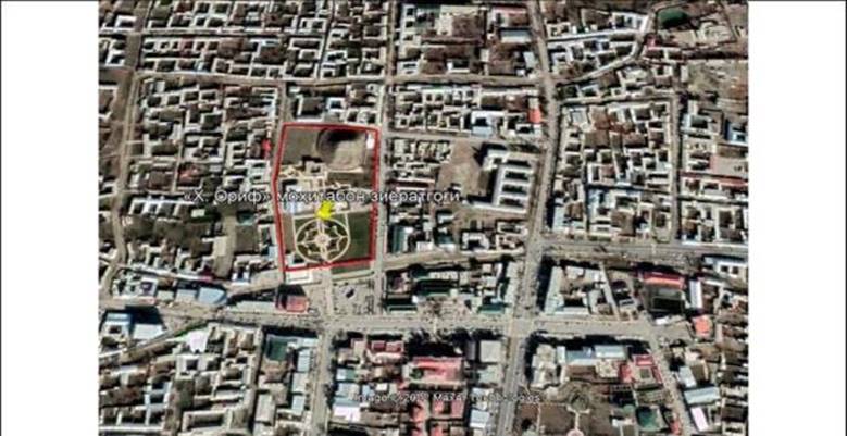
Khuja Arif ar-Revgari Mohitoban shrine
Object
type: Attractions
The
year of birth of Khoja Arif Revgari kuddisa sirruhu (may God bless his secret)
is not clear. He died in Revgar in 1237-38 AD (635 AH).
Khojagon is the first BuFin
shaykh of the Naqshbandi order, the second of the seven pirs of Bukhara Sharif,
whose full name is Khoja Muhammed Arif Revgari. Arif Revgari's teacher
Abdulkhalik Fijduvani is the fourth caliph of His Holiness. The village of
Revgari is located 36-38 kilometers from Bukhara. This address is in the city
of Shafirkon.
Fakhriddin
Ali Safi (1463-1503) in his work entitled "Rashokhatu ainil Khayat"
mentions that Khwaja Arif Revgari was from the Revgar Dakha of Bukhara, he was one
of the beloved students of Abdulkhalik Fijduvani, and Khwaja Bakhouddin
Naqshband (1318-1389) praised him with respect: "Khwaja Arif Revgari
Khwaja Abdulkhalik Fijduvani is the fourth caliph from the successors of
Kaddasallahu ta'ala sirrahu. Mawlid and his graves are Revgardirkim, one of
Bukhara's dakhas, six farsakhs away from the city. From there to Fijduvan,
there is a Sharia farsakh." In this work, it is emphasized again that:
"Khuja Arif kuddisa sirruhuFa etushur is the service of Khwaja Abdulkhalik's
caliphs, the proportions and wills of Khdzrati Khwaja Bahauddin kuddisa sirruhu
Fa etushur."
After
the death of Arif Revgari Abdulkholik Fijduvani, he headed the Khojagan sect of
Sufism, the shoshu gado ran to his presence and the people started calling him
"Mokhitoban" (the moon that illuminates the darkness). He reached a
high level due to his strictness in following the Sunnah of our Prophet (pbuh).
After Abdulkhalik Fijduvani's death, he showed sincere devotion and faith in
continuing his life. That is why His Holiness Muhammad Bahauddin Naqshband, who
came four generations after him, followed in their footsteps, benefited from
their spirituality and became famous in the world.
The
only known work of Arif Revgari is "Orifnama". Along with the thoughts
of the first Sufis, sources from his teacher Abdulkhalik Fijduvani were also
used in this work. His Holiness Arif Revgari advises tax collectors and readers
who read this book. In the work "Matlab ut-talibin" by Muhammad
Talib, the words of Khoja Arif are recorded: "The one who obeys the plan,
the one who rejects the destiny is in heaven, and the one who surrenders to the
divine destiny is in heaven."
In 1993, on the occasion of the 675th
anniversary of Bakhovuddin Naqshband, the manuscript of Revgari's work
"Orifnama" was presented to Bukhara scholars by Pakistani Naqshband
scholars. This work was written by Arif Revgari in the year 622 Hijri (1225
Melody) at the request of Khwaja Na'im in the town of Nur.
region
(city): Bukhara region
district:
Shafirokon district
Name of local community center: Khoja Arif MFY
street
name (or other identifying address): Tagiteppa Street
Period:XVII
century
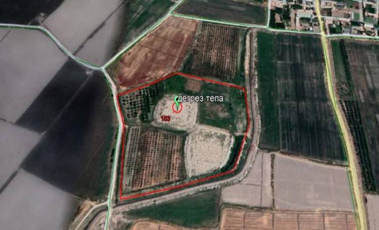
Degreztepa
Object Type:
Archaeology memorial
The monument is located 500 m southwest of Degrez village.
It consists of two parts: the castle and the adjacent residence. The fort part
is in the form of a lower square on an oval angular plan, 90 m along the
west-east line and 100 m along the north-south line. The height reaches 15 m,
the standard part of the triangulation point is partially preserved. The
neighboring settlement is located in the south-east of the castle and is
connected to it in the form of an isthmus with a width of 17 m. The size of the
castle is 100 m in the north-south direction, 70 m in the west-east direction.
In the north, the settlement was lowered, up to 2 m in height, and in the
southern part, up to 5 m. Earthworks affected the neighboring settlement, a
bulldozer was cut to a depth of 16 m from the north. A triangulation tower is
partially preserved on top of the castle part. In the part of the castle, the
remains of the southeast corner tower and three towers on the west side,
including the southwest corner, are preserved in relief. The towers are made of
clay bricks measuring 31x21x9 cm. The monument can be classified as a fortress
with a neighboring settlement.
region
(city): Bukhara region
District:
Kogon District
name
of neighborhood assembly:"Khoja Yakshaba" MFY
street
name (or other identifying address):Degrez village.
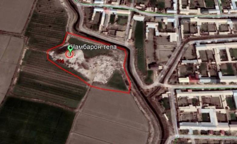
Chambarontepa
Object Type:
Archaeology memorial
The
monument stretches along the west-east line at the southern edge of Chambaron
village. It consists of 2 parts: the castle in the western part and the
adjacent settlement. The dimensions of the castle along the north-south line
are 55 m, along the west-east line 45 m, the height is 10 m. The dimensions of
the upper platform of the castle are 16x12 m. The castles are very steep,
almost. transparent. The surface is quite densely peated. The width in the western
part of the village is 30 m, and in the wider eastern part it is 72 m. The
height of the neighboring town is about 3 m. The monument can be classified as
a fortress with a settlement adjacent to it.
Period:IV
- VIII centuries
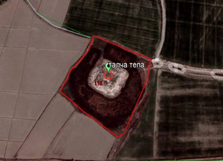
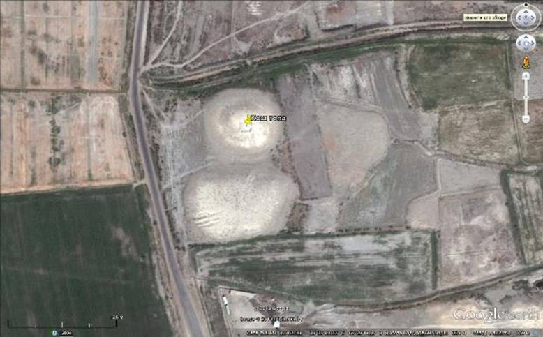
Talchatapa
Object Type:
Archaeology memorial
The
monument is located 300 m southeast of Talcha village. The top is sub-square in
shape and oriented to the cardinal points. It is 47 m long in the west-east
direction, 46 m in the north-south direction, and 4 m in height. Covered with
salt powder. The surface is not smooth, probably damaged by machinery. The area
around the monument is low, flooded, and overgrown with reeds. There is no
lifting material. It is probably the remains of an early medieval manor.
Period:Middle
Ages
Kerjaktepa
Object Type:
Archaeology memorial
The monument is located one and a half kilometers
southeast of the Bahauddin Naqshbandi architectural complex and 50 m south of
the main road. The upper platform is flat, on it are the remains of a destroyed
benchmark. Its dimensions are 150 m along the north-west-east line, 210 m along
this line from the south, 170 m along the north-south line from east, 160 m
from the west. Its height reaches 14 m. There are soft barriers to descend from
the north, along the road and from the south-east side. The slopes are covered
with salted powder. Lifting materials IV-VIII and X-XII centuries.
The
monument can probably be classified as a small settlement.
Period:IV - XII
centuries
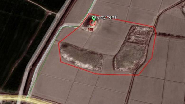
Yaglovtepa
Object Type: Archaeology memorial
The
monument is located 100 m northeast of Yaglou village, 500 m west of Upper
Khanzi village. It consists of a fortress part and two separate massifs, which
form neighboring settlements. The part of the castle is rectangular in plan, its
dimensions are 46 m along the north-south line, 35 m in the west-east
direction, and its height reaches 11.5 m. The dimensions of the upper platform
are 30x15 m. The first massif is located 55 m south of the castle, its
dimensions are 40 m along the north-south line, 110 m along the west-east line,
and its height reaches 5 m. 20 m east of the first massif is the second massif,
extending 170 m from north to south and 68 m wide along the west-east line, the
height of the second massif reaches 3 m in the southern part, 1.5 m. northern.
The northern part was significantly damaged. On the eastern side, at a distance
of about 100 m. low remains that belong to the monument and occupied by the
modern grave are observed. Lifting materials IV-VIII centuries. Presumably, the
monument can be classified as a fortress with a settlement.
Period:IV - VIII
centuries
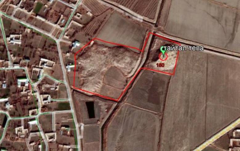
Taytaltepa
Object Type:
Archaeology memorial
The
monument is located in the territory of Taytal village. Elabad village is
located 400 m east of the monument. It consists of a castle part and a separate
neighboring settlement. The dimensions of the castle along the west-east line
are 93 m, along the north-south line 112 m, and the height reaches 8 m. 30
meters west of the castle, the first rectangular massif is 93 m along the
west-east line and 112 m along the north-south line. The height of the first
massif reaches 5 m. Its northwestern side is connected with the second massif
by an isthmus. The second massif is badly destroyed, its preserved height is up
to 3 m, only its contours can be observed. The front dimensions of the second
massif (along the contours) are 186 m along the north-south line and 98 m along
the east-west line. The bearing material dates back to the 4th-8th centuries.
There are also pieces of pottery from the 18th-19th centuries.
Period: IV - VIII centuries
Koshtepa
Object Type:
Archaeology memorial
The monument is located in the steppe zone (9 km from
the turn to Kogon). The nearest village Chukur Kol is in the northwest. 100 m from
the west to the monument is a road. It consists of a fortress and a fortified
neighboring settlement 25 m away from it. The base of the fort and the
settlement seem to have merged in the past, but now a dirt road runs between
them. The plan of the castle is almost circular, its diameter is around 100 m,
and its height is up to 12 m. The dimensions of the annexed settlement are 140
m along the west-east line, 66 m along the north-south line, and the height
reaches 5-6 m. From the west, there are bulldozer tracks on the side of the
road. From the east of the castle and the settlement, along the north-south
axis, slag flows with a width of 30 to 50 m and a thickness of 1.5 m extend for
a distance of 160 m. The settlement was littered with pottery and slag fragments.
Undoubtedly, in the past, there was a large-scale pottery production here,
dating back to the beginning of the 12th and 13th centuries. The slopes are
covered with salted powder. The bearing material dates back to the 4th-8th
centuries. and early XII-XIII centuries. A brick factory is located in the
south of the monument. Presumably, the monument is a small settlement with a
separate fort.
Period:IV - XIII
centuries
Shrine of Syed Mir
Kulol
Object type:
Attractions
Hazrat
Sayyid Amir Kulol was the sixth of the famous 7 pirs of the
Khojagon-Naqshbandiya sect in Bukhara Sharif. His real name is Sayyid Amir
Kalon al-Sukhori. The origin of his father Amir Hamza is from Hijaz, and he is
considered a descendant of our Prophet Muhammad Mustafa, may God bless him and
grant him peace. They met Amir Kulol when they were 15 years old and were in
his service for 20 years, studied the Quran, Hadith, Sufism and received the
title of "Sayyidul Orifin" - sayyid of the saints. 772 (melody 1370)
the place of his death is in the village of Suhob (Kagon district). Before
independence, these were the only graves of this breed.
Period:XVI-XX
centuries
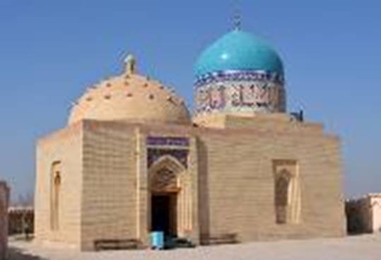
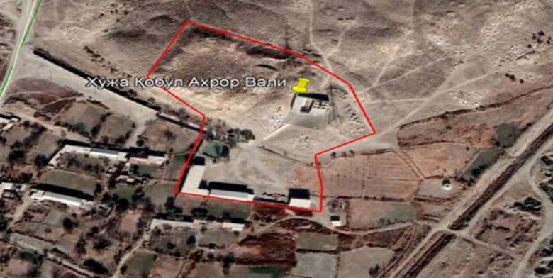
Tomb of Khwaja
Kabul Akhbar Vali
Object type:
Attractions
Period:XVI
century
Also known as Khoja Khoshkap Ato, there is a shrine
"Khoja Kabir Ahror Vali", this ulama lived approximately in the 7th
century and his grave is also located in the present "Khoja Kabir Ahror
Vali" shrine. The length of the tomb of "Khoja Kabir Ahror
Vali", who was given the title of "Informer of History", has
been estimated since the 7th century.
Bahauddin
Naqshband Complex
Object Type:
Architecture memorial
Hazrat
Bahauddin Naqshband (may God bless him and grant him peace) is known in the
Muslim world as "Sheikh Bahauddin", "Khojai Buzurg",
"Shah Naqshband" and was born in 1318 in the village of Qasri Orifon
near the city of Bukhara in the family of a weaver craftsman. After their
birth, the village is still called Qasri Orifon. His full name is Sayyid
Muhammad ibn Sayyid Muhammad Jalaluddin Bukhari. The nicknames of Mubarak are
Baha ul-Haq (Light of Truth), Baha ud-Din (Light of Religion), Baha ul-Milla
(Light of the Nation). Khwaja Bahauddin Naqshband was born in Qasri Orifon in
1318 (XIV century) and learned from Khwaja Babai Samasi. He had many students
who were trained in weaving and embroidering. When exploring this shrine,
Abdulaziz Khan Khanaqah, Bohouddin Naqshband Dakhm, Muzaffar Khan Mosque, Abul
Hakim Qushbegi Mosque, Amir Ubaidullah Khan Dakhm,
Period: XIV-XX
centuries
Kazakh
Khonimtepa
Object
Type:Archaeological monument
The monument is
located in the southwest of Yurunbolo village, in the north of Rabat village.
The rectangle is small, its dimensions are 90 m along the north-south line, and
about 70 m in the east-west direction. Its height is 10 m. . In the middle
part, on the eastern side, a room with an area of 15 by 10 m has
been preserved, and in the northern part, the walls of several more rooms can
be observed. There is an old swollen ditch in the upper part of the northern
slope. Raw fish of size 40 x 24 x 9 cm are recorded in Kalamchas.
The top is a large cache fort with corrugated iron
walls typical of the early centuries.
region (city): Bukhara region
district: Bukhara district
Name of local community: Yangiabad»
MFY
Kucha name (or other identifying
address): Yurunbolo village
Period: I - XVI centuries
Turkan Khachirtepa
Object type: Archaeological monument
The monument is located on the northern edge
of the Turkon village, not far from the South-Farby administrative border of
Bukhara region. The highest height reaches 12 m. There is a triangulation tower
in the upper part. Busy under the grave. In some places of Tot yonbaFirs, there
are traces of destruction due to excavation. According to local residents, the
memorial area has been enlarged. Extimol, in the main massif, to the south of
it, there was a kushan settlement destroyed by two fish factories operating in
this area. Carrying material of the 1st century. Until the XVII-XVIII
centuries. Unglazed 3rd century ceramics: cups, bowls, bowls, bowls are
preferred. Also, fragments of glass vessels dating back centuries,
region (city): Bukhara region
district: Bukhara district
The name of the local residents' yitini:
"Turkon" MFY
Kucha name (or other
identifying address): Turkon village
Period:
I--XVIII centuries
Kush
Talalien.
Object type: Archaeological monument
The monument is
located in the north-western edge of the village of Kulonkhan, a large
settlement with a triangular plan, extending 230 m along the north-south axis
and 120 m along the width direction. In the highest places, the height reaches
11 m. Corner towers stand out. In the structure of external fortifications,
straw blocks can be seen in places. The upper platform of Kishlok was occupied
by a cemetery, which changed many places from many burials. In the lower areas,
the height is 6-7 m above the daytime level. Anticipation of dating material -
from the 1st century to the beginning of the 7th century. In the waiting
material, there are predominance of unglazed bowls and bowls of the X-beginning
of the 32nd century.
region (city): Bukhara region
district: Bukhara district
Name of local residents' yeti:
"Kulonkhona" MFY
Kucha name (or other identifying address):
Kulonkhana village
Period:
X — XIX centuries
Tali Arabkhana
Object type: Archaeological
monument
The settlement is located in the north of the 16th century
architectural complex. Chor Bakr. It consists of the main building and two
adjacent residences. The main fortress is a large hill oriented in the
north-west-south-east direction, the area of which is
approximately 180x100 m, and the steep sides are up to 14 m high. because, most
likely, the gate will be visible. The first Kushni settlement adjacent to the
hill from the south-shark. It is rectangular in shape, its area is 160x200 m,
and its height reaches 6 m. It is connected to the main hill with a bridge
arch. The second additional massif is located to the north-east of the main
hill. It is a pear-shaped low hill no more than 2 meters high. The length of
the settlement is 100 m, the width is from 30 m to 90 m. No waiting material
found. Excavation traces were recorded on the top of the main hill (1971, under
the leadership of Akhrarov).
region (city): Bukhara region
district: Bukhara
district
The name of the
neighborhood public school is "Shergiron" MFY
Kucha name (or other identifying address):
Shergiron village
Period: Middle Ages
Sultan Sheikhali Bobotepa
Object
type: Archaeological monument
The monument is
located on the south-western border of Bukhara region with Zhondar region, in
Farbi of Podshoy village. It is a rectangular settlement with an area of
220x120 m in the north-east direction, and the highest height of
the hill in the central part is 14 m. A triangulation tower is installed in the
upper part.
Material
waiting for urtas of the IV-V centuries. Until the XI-XI centuries.
region (city): Bukhara region
district:Bukhara district
Name of neighborhood football club:
"Podshokhi" MFY
Kucha
name (or initializing address): Tsarshoi Tshlog
Shexantepa
Object
type: Archaeological monument
The
monument is located south of the village of Shaykhon. It is an oval hill
extending to the north-west and south-east, with an area of
approximately 1 ha. The height of the hill reaches 11 m, the
sides are steep. To the south of the main hill, there was once a large kushan
settlement, now completely plowed and destroyed by the Fisht factory. Pottery
belonging to the 4th-5th centuries was found on the surface of the plowed
settlement. Later pottery of the 7th-8th centuries is on the main hill.
region (city): Bukhara region
district: Bukhara district
name of local community: "Rabotikalmok" MFY
Kucha
name (or other identifying address): Sheykhan village
Period: IV - VIII centuries
Chor Bakr complex
Object Type:Architectural monument
Chor Bakr shrine is located in Farb, 6 km from
Bukhara city, the ancient name of this area is Sumitan. According to the book
"Fiyosul-luFat", the meaning of Sumitan suzi means "the place
where woolen cloth weavers live". In the 10th century, a gate arch named
Khodsharun from Bukhara was brought to the village of Sumitan. Khodsharun Gate
was called Talipoch, i.e. "Khan's Hill" in the 15th-16th centuries.
Four great saints - Hazrat Abu Bakr Sa'd Yamani (died 970), Hazrat Abu Bakr
Hamid (died 937), Hazrat Abu Bakr Muhammad ibn Fazl (died 991), Hazrat Abu Bakr
Tarkhan (died 945), this topic is Char Bakr , that is, it was called turtta
Bakr.
Looking at the historical narratives, the
families of the Chor Bakrs go back to our Prophet Muhammad (pbuh). According to
the information provided by the historian Muhammed Narshahi in his book
"History of Bukhara", in 889 Ali ibn al-Husayn defeated Khorasan and
came to Bukhara along the Amudarya River. Amir Ismail Somani welcomes him very
well. Together with Ali ibn al-Husayn, the famous Char Bakrs - Abu Bakr Sa'd
Yamani, Abu Bakr Hamid, Abu Bakr Fazl ibn Ja'far, Abu Bakr Tarkhan also visited
this beautiful country and stayed here for a lifetime. The Chor Bakrs, who are
descendants of Ja'far and Ali, gathered around the branch of Bukhara and made a
great contribution to the spread of science and knowledge. According to
historical sources, Amir Ismail Somani donated countless lands to the saints of
Chor Bakr. And they distributed the income from the wakf lands to the nation.
spent for the improvement of the country. They built a shelter for the
homeless, taught knowledge to those who sought knowledge, showed the way to the
lost, served the sick and orphans impartially, in a word, served the people
with pleasure in order to find the pleasure of Allah. For thousands of years,
descendants of Chor Bakr have gained great influence in Bukhara and
participated in the knowledge and spiritual life of these lands. The rulers of
Bukhara always reckoned with them. Those who received advice in times of
trouble. They relied on their help in the struggle for peace and tranquility of
the country. For thousands of years, descendants of Chor Bakr have gained great
influence in Bukhara and participated in the knowledge and spiritual life of
these lands. The rulers of Bukhara always reckoned with them. Those who
received advice in times of trouble. They relied on their help in the struggle
for peace and tranquility of the country. For thousands of years, descendants
of Chor Bakr have gained great influence in Bukhara and participated in the
knowledge and spiritual life of these lands. The rulers of Bukhara always
reckoned with them. Those who received advice in times of trouble. They relied
on their help in the struggle for peace and tranquility of the country.
The Chor Bakr complex in Sumitan consists of
family huts and huts connected to each other, the front of which is surrounded
by a solid wall with pediments and cells. This complex, known as Chor Bakr, is
considered one of the most wonderful examples of Middle Asian architecture, and
the methods of the Bukhara school of architecture of the 16th-17th centuries
are clearly expressed in it. The huts and huts are very well made, the walls
are surrounded by tiled walls, there is a mekhrobin door that leads inside, and
there are rooms on both sides of the miyonsarai (hallway).
region (city): Bukhara region
city: Bukhara district
Name of local public school: "Shergiron" MFY
Kucha
name (or other identifying address): Shergiron village
Period: XVI-XX acp
Hazrat Baba Mosque
Object type: architecture
This
facility is located in the village of Tagitut, Kunji Castle MFY. It is
surrounded by a fence. It consists of a g-shaped porch, renovated by the local
population with the patronage.
region
(city): Bukhara region
city: Bukhara
district
the name of the local
community gathering: "Khumin" MFY,
Kucha name (or other
identifying address): Khuja Chakmok village
Period:
XVIIIacp
Khuja Chakmok Mosque
Object type: architecture
This
facility is located in the village of Chakmok, Khomin MFY. The mosque consists
of a G-shaped porch, and was renovated under the patronage of the local
population during its construction.
region
(city): Bukhara region
city: Bukhara
district
name of the local
community gathering: "Khumin" MFY,
Kucha name (or other
identifying address): Chakmok village house number:
Period:
XVIIIacp
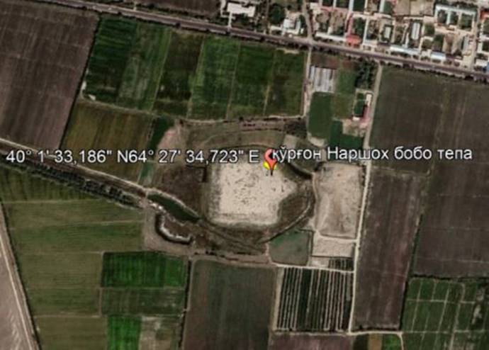
Kurgan Narshok Bobotepa
Object Type: Archaeology
memorial
This hill was built in the 9th century. On
top of the hill was the headquarters of Muqanna. Height 9-10 meters. It is
located in the territory of the Latifsobungar neighborhood of Tepalik district.
Kurgan Narshakhbaba hill is currently called Abu Bakr ibn Muhammad An Narshahi
cemetery. There is no complete information about the history of the hill, which
has been fenced off and beautified. Due to the fact that no archaeological
excavations have been carried out, precise scientific conclusions have not been
given.
region (city): Bukhara region
district: Wobkent district
name of neighborhood assembly:"Latifsobungar"
MFY
street name (or other identifying
address):Narchak village
Period:Middle
Ages
The name of the object:
Tali Peshmontepa
Object Type: Archaeology
memorial
Tali Peshman tepa was founded in the middle ages, and
the tepa Latifosobungar neighborhood is located in Talpushman village. The area
occupies 33 hectares of land. There is no complete information about the hill.
Due to the fact that no archaeological excavations have been carried out,
precise scientific conclusions have not been given.
region (city): Bukhara region
district: Wobkent district
name of neighborhood assembly:"Latifsobungar"
MFY
street name (or other identifying
address):Talpeshman village
Period:Middle
Ages
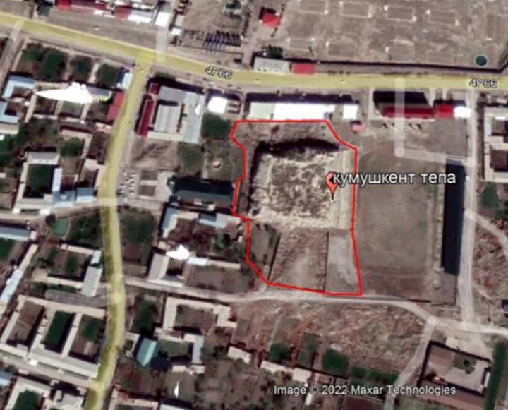
Kumushkentepa
Object Type: Archaeology
memorial
Kumushkent hill is located on approximately 1 hectare
of land and has more than 50 acres. This hill was built around the 9th century.
He also fought Arab and Mongol battles
region (city): Bukhara region
district: Wobkent district
name of neighborhood assembly:"Khalvogaron"
MFY
street name (or other identifying
address):Kumushkent village
house number:
Period:Not
defined
Republic/local/ Republic
Chillatepa
Object Type: Archaeology
memorial
In the
early Middle Ages, the Khojarabod neighborhood of the present Vobkent district
was located in the village of Khojarabod and was built over 15 meters high.
Various stories have been told about the hill by local residents. At the same
time, the hill is also called Stork Hill. The total area of the
hill and the cemetery is 0.28 hectares.
region (city): Bukhara region
district: Wobkent district
name of neighborhood assembly:"Khojarabod"
MFY
street name (or other identifying
address):Khojarabod village
house number:
Period:Not
defined

Sufi
Dehkhan Khanaqo
Object Type: Architecture
memorial
Bukhara, Vobkent districtSamarkandandTashkentwithbinder carlocated on the side of
the main road. From the middle of WobkentZarafshona tributary of the
river was crossed by the Vobkent river. It is located 28 km northeast of
Bukhara.
of the districtSufi Dehkan neighborhood is under
state protection, there is a Sofi Dehkan khanaqah, built in the architectural
style of the 17th-18th centuries. Local raw materials such as brick and wood
were used in the construction of the room.
region (city): Bukhara region
district: Wobkent district
name of neighborhood assembly:"Sufidehkhan"
MFY,
street name (or other identifying
address):Sufidehkhan village
house number:
Period:Unidentified
(17th century)

Chashma
Ayub Khazira
Object
Type: Architecture memorial
Chashmai Ayub Khazira was
built at the beginning of the XIII century (1208-1212), and according to the
narrations, when Abu Faad Al-Kharjo'shi, a scholar of hadith studies, came to
this area, a spring gushed out from under his feet. Hadith scholar died in
1017. It was created 90 years after his death. Today, only part of the gate is
preserved in this place. Today, there are three (3) historical monuments named
after Chashmai Ayub in Uzbekistan, the first one is located in Kashkadarya
region, the second one is in Bukhara city, and the third one is in Vobkent
district. There is Chashmai Ayub Jame Mosque in its territory, which was built
in the 19th century. On the front of Chashmai Ayub's shrine is written a
hadith.
Muhammad (pbuh) narrates:
"I forbade you to visit the graves, but now you can visit the graves"
region
(city): Bukhara region
district:
Wobkent district
name
of neighborhood assembly:"Pushmon" MFY,
street
name (or other identifying address):Khairabotcha
village
house
number:
Period:
XIII century

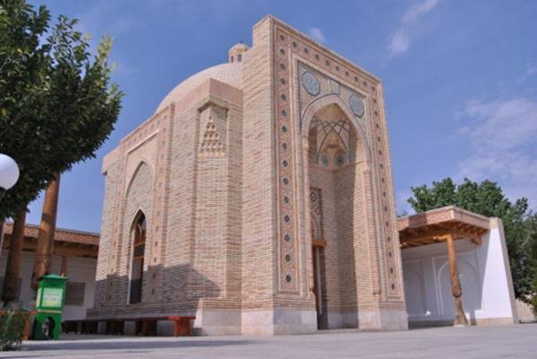
Vobkent
tower
Object
Type: Architecture memorial
The tower in Vobkent is a conical
tower-type structure, round in plan, and the balcony part is in the form of a
lantern. The total height of the tower is 40.3 m, the lower diameter of the
shaft is 6.19 m, and the upper one is 2.81 m. The area where the monument is
located was central in the past. A mosque with a tall porch is adjacent to it
from the north-west side. It is possible to speculate about the later date of
the construction of this mosque. This version is probably consistent after a
careful study of a historical photograph taken in the first half of the 19th
century.
P.I. Lerkh, who visited Wobkent on
November 1, 1858, wrote that a large mosque was attached to the minaret, and
the staircase rising above the ground is evidenced only by the door accessible
from the roof of a nearby building. Based on the analogy, we can say that
mosques of this type with high and deep wooden porches began to be built
everywhere in the 15th and 16th centuries. It is known that during the Islamic era,
only mosques were built later on the main location of the mosque.
By studying the traditions of building
towers in the Bukhara oasis, one can guess about the criteria for choosing a
place for construction. Since the tower is a very massive structure, the
location was chosen based on the characteristics of the soil and its physical
properties. Similar to the Bukhara tower, the Vobkent tower was built later on
soils that do not settle very well. Thus, in Bukhara, the minaret was built on
the bank of the canal, the natural channel of the Zarafshan River, which
existed long before the construction began.
So, the construction process of the
Vobkent tower was the same, starting from the selection of the place for
construction, and it would be correct to assume that one of the channels of the
Vobkent river flowed nearby in the past. Today, the buildings bordering the
square around the tower have a modern look. Except for the 16th century
building of Abdulaziz Khan madrasa.
region
(city): Bukhara region
district:
Wobkent district
name
of neighborhood assembly:"Vobkent" MFY,
street
name (or other identifying address):I. Bukhari Street
Period:1197
year

Khoja Mahmud Anjir Fagnawi shrine
Object type: Attractions
Hazrat
Khoja Mahmud was born in the village of Anjir Fagni, Anjir Fagnavi Vobkent
district, around 1210 and died in this village in 1286.
This
noble breed was of medium height, white skin, well-shaped nose, wide mouth,
handsome beard, bright face. They wore white turbans on their heads, and they
had a lot of charms.
According
to the sources, Khoja Mahmud was an example for everyone in piety, asceticism,
and contentment.
Hazrat
Khwaja Mahmud Anjir Fagnavi's "Nafohatul Uns" by Abdurrahman Jami,
"Nasaimul Muhabbat" by Alishsr Navoi, "Rashahotu Ainul
Hayat" by Ali Safi, "Hazarotul Quds" by Badridtsin Sarhindi,
"Matlabul Talibin" by Muhammad Talib, "Jami'us Salosil" by
Majiduddin Badakhshani, Tahir Information is given in Eshon's "Tazkirayi
Naqshbandiya", Nasiriddin Tora's "Tuhfat az Zahirin" and other
works.
Sufists
such as Najmiddin Komilov, Mahmudkhan Hasani, Gulchehra Navro'zova, Narzulla
Yoldashev, Hamidkhan Islami, Samad Azimov, Mirzo Kenjabek, Sayfiddin Sayfullah,
Aygul Sharipova, Nodirkhan Hasan have published scientific articles on the
rights of Hazrat Khoja Mahmud Anjir Fagnavi. Khwaja Mahmud is considered to be
the piri murshid of the twelfth circle in "Silsilai Sharif", a great
educator, scholar, and guardian.
In
the sources, the professions of this breed of Sharif are said to be plasterers
and carpenters. The current name of Khoja Mahmud's native village is Anjirbagh.
If
you pass the Tabarruk Minaret in the center of Vobkent district and turn left
on the way to Shafirkon district, the road will take you to the shrines of
Khoja Mahmud Anjir Fagnavi. The name of the shrine is written at the beginning
of the main road.
region (city): Bukhara region
district: Wobkent district
name of neighborhood assembly:"Andjirbog"
MFY,
street name (or other identifying
address):Andjirbog village
Period:XVI
century
Varakhsha
city
Object
Type:Archaeological monument
Varakhsha is ancientcityruinFrom
Bukhara40 km north-west, Dashti Urganjiof
the lakeof ancient Rajfanin the oasisis
located. Varakhsha square 9toand was preserved
in the form of a huge hill with a height of 10-20 meters.
Varakhsha
and its surroundingsV. A.
Shishkin(1937-39, 1947-54) conducted extensive archaeological
research;A.
Muhammadjanov(1975-77), O. V. Obelchenko (1977-79), G. V.
Shishkina (1987-90) also conducted excavations in some parts of Varakhsha.
According to archaeological excavations, Varakhsha av. Several contiguous in
the 2nd centurystrongvillagesrose in style.
Ancient
to the north-west of the ruins of Varakhshafrom the fortressesone of them has
an outer wall and a semi-circular inner space of 4.5×5 meterszodiac signdug
and studied. The thickness of the wall is 1.8-1.9 m and the size is
37×41×10 cm.from brickbuilt. The inner side of
the walls and towers is 38-40 cm, the outer side is 75-80 cm, and the width is
20-22 cm.squishytarget
holes are opened.
Mil.
av. In the 2nd and 1st centuries and Cultural life flourished in Varakhsha and
its surroundings in the 1st-2nd centuries. In the 3rd and 4th centuries,
Varakhsha fell into decline. In the 5th century, Varakhsha was restored and the
ancient rulers of Bukhara -steam godshas
become a residence. During this period, Varakhsha was surrounded by a strong
wall, in its southern partarchbuilt.
It was particularly prosperous in the 8th-10th centuries. Varakhsha and its
surroundings were irrigated by 12 canals and became one of the largest and
central forts in the Rajfandun oasis.
Bukhara
andKhorezmbetweencaravanthe road passed through
Varakhsha[1]. Every fortnight, a one-day
market sale was held in Varakhsha, and at the end of the year there was a
20-day market sale (Navrozi kasho varzon, i.e. the farmers' new year).[2].Steam godsVarakhsha
became a big city after its settlement. In the 11th and 12th centuries, its
territory was more than 6 km wide. In the 12th century, life in the oasis of
Varakhsha came to a sudden halt for unknown reasons.
region
(city): Bukhara region
district:
Jondor district
name
of neighborhood citizens' assembly: "Romish" MFY
kucha
name (or other identifying address): Located in Varakhsho chul tsim
Abduholiq
G'ijduvani complex
Object type:
Architectural monument
The murshid of the Khojagan Sufi sect, and later the true founder
of the Naqshbandi sect and teachings, is the great humanitarian Sufi Abdukholiq
G'ijduvani. The great mystic scholar, Sheikh Abdukholiq Gijduvani was the
fourth half-brother (murid) of Khoja Yusuf Hamadani, who was born in 1103 in
the city of Gijduvan. He wrote many works dedicated to mysticism and Sufi
culture.
Abdurrahman Jami, a respected writer and thinker of the 15th
century, left encyclopedic information about the great figures of Sufism. There
are information about Abdukholiq G'ijduvani written by this great man in 2
works: "Nafahotul uns" and "Bahoristan". "Nafahotul
uns" (Joyful Gifts") Abdurrahman Jami's taziz containing the
biography and works of Sufism was written in 1475-1476. The work contains
information about more than 600 representatives of Sufism who lived in
different eras. On pages 242-243 of the work Hazrat Khoja Abdukhalik G'ijduvani
Alisher Navoi was inspired by these works and created a work called
"Nasoyimul Muhabbat".
The author of the historical work "Abdullanoma" Hafiz
Tanish Bukhari (XVII century) respectfully mentions the names of the nobles as
"Khojai Jahan Khoja Abdulkhaliq Gijduvani". It is clear from this
that he was called Khojai Jahan, the year of his birth in 1111 and his death in
1179 are indicated in this source. Their graves are indicated as being in their
native land, Gijduvan.
region
(city): Bukhara region
City:
Gijduvan district
name
of neighborhood citizens' meeting: "A. Gijduvani» MFY
street
name (or other identifying address): A. Gijduvoni street
Period: XV-XXI acp